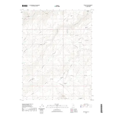
2020 Map of Twin Hollow
USGS Topo · Published 2020About this map
Horse Haven Summit stands as a prominent high point in this remote stretch of Carbon County, where high plateaus and deep drainage systems define the landscape. The geography is characterized by a series of significant ridges and mesas, including Cottonwood Ridge and Bishop Ridge, which separate various canyons and draws. This 2020 survey reveals a land primarily used for ranching and resource access, with an extensive network of rugged roads like Bishop Ridge Rd and Flat Canyon Overlook Rd connecting vital water sources such as Buckhorn Spring and Petes Spring. The presence of Dry Farm Flat and Sage Brush Flat among the more dramatic features like Cedar Corral Canyon suggests the historical agricultural and grazing utility of these high-elevation plateaus, providing a clear picture of the region's contemporary land management and topography.
Find a feature on this map
39 named features on this map. Tap any name to fly to it.
Don’t see what you’re looking for? This feature index may not catch every label — zoom into the map to look around manually.
Map Details
Editions of this 2020 Twin Hollow Map
This is the sole edition of this map. No revisions or reprints were ever made.
Other maps of this area

1886 · Price River
USGS Topo · 1:250,000

1896 · Price River
USGS Topo · 1:250,000

1915 · Sunnyside
USGS Topo · 1:62,500

1954 · Flat Canyon
USGS Topo · 1:62,500

1956 · Price
USGS Topo · 1:250,000

1960 · Price
USGS Topo · 1:250,000

1962 · Price
USGS Topo · 1:250,000
1968 · Cowboy Bench
USGS Topo · 1:24,000
1968 · Pinnacle Canyon
USGS Topo · 1:24,000
1968 · Currant Canyon
USGS Topo · 1:24,000