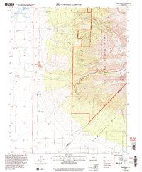
2001 Map of Twin Peaks
USGS Topo · Published 2005About this map
The Pioneer Urraca Cem stands as a quiet marker of early settlement at the edge of the Sangre De Cristo Wilderness and the Rio Grande National Forest. This landscape is defined by the transition from high-desert valley floor to the soaring peaks of the Sangre de Cristo range. Agricultural and ranching interests are evident at the King Ranch and the community of Piedmont, supported by water management features like the Holbrook Creek Dam, Tobin Creek Dam, and the Garland Ditch. Higher elevations reveal a topography of deep drainages such as Urraca Canyon and Chokecherry Canyon, leading up toward Twin Peaks. Evidence of historical industry is found at the Swab Mine and along the Stock Driveway, while natural landmarks like Zapata Falls and alpine waters including Lake Como and Blue Lakes highlight the area's diverse terrain.
Find a feature on this map
41 named features on this map. Tap any name to fly to it.
Don’t see what you’re looking for? This feature index may not catch every label — zoom into the map to look around manually.
Map Details
Editions of this 2001 Twin Peaks Map
This is the sole edition of this map. No revisions or reprints were ever made.
Other maps of this area

1889 · Huerfano Park
USGS Topo · 1:125,000

1892 · Huerfano Park
USGS Topo · 1:125,000

1954 · Trinidad
USGS Topo · 1:250,000

1955 · Trinidad
USGS Topo · 1:250,000

1958 · Trinidad
USGS Topo · 1:250,000

1959 · Trinidad
USGS Topo · 1:250,000

1965 · Medano Ranch
USGS Topo · 1:24,000

1965 · Blanca
USGS Topo · 1:24,000

1965 · Zapata Ranch
USGS Topo · 1:24,000

1965 · Baldy
USGS Topo · 1:24,000