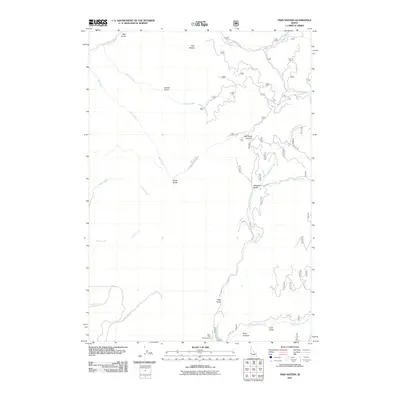
2011 Map of Twin Sisters
USGS Topo · Published 2011About this map
Twin Sisters defines the high northern landscape of this Idaho quadrangle, presiding over a complex network of drainages that feed into the Little Weiser River and Squaw Creek. The 2011 survey reveals a territory primarily shaped by forestry and water management, evidenced by the many Forest Service routes like NFD 818 Rd and NFD 853 Rd that penetrate the canyons. This map is particularly notable for identifying the Third Fork Project Camp, situated near the confluence of Third Fork Squaw Creek and several steep-walled features such as Bear Gulch and Buck Canyon. The geography here is marked by significant topographical landmarks like Mill Creek Summit, which serves as a natural divide between the north-flowing Mill Creek and the southern watershed. Named features such as Lava Gulch, Woodard Gulch, and Four Bit Creek provide specific points of reference for those tracing local place names or exploring the drainage patterns of Gem County.
Find a feature on this map
25 named features on this map. Tap any name to fly to it.
Don’t see what you’re looking for? This feature index may not catch every label — zoom into the map to look around manually.
Map Details
Editions of this 2011 Twin Sisters Map
This is the sole edition of this map. No revisions or reprints were ever made.
Other maps of this area

1894 · Squaw Creek
USGS Topo · 1:125,000

1911 · Meadows
USGS Topo · 1:125,000

1953 · Smiths Ferry
USGS Topo · 1:62,500

1954 · Council
USGS Topo · 1:62,500

1954 · Cascade
USGS Topo · 1:62,500

1955 · Baker
USGS Topo · 1:250,000

1959 · Baker
USGS Topo · 1:250,000

1970 · Dodson Pass
USGS Topo · 1:24,000

1970 · Granger Butte
USGS Topo · 1:24,000
1970 · Riley Butte
USGS Topo · 1:24,000