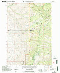
2004 Map of Twin Sisters
USGS Topo · Published 2007About this map
Twin Sisters towers over a landscape defined by the intersection of the Payette National Forest and Boise National Forest in central Idaho. Revised in 2004, this topography highlights a complex watershed where the Little Weiser River and Middle Fork Weiser River drain the high country. The map captures the administrative junction of Adams, Gem, and Washington counties, providing a clear picture of the Forest Service boundaries within the Council Emmett Ranger District. To the southeast, Lava Ridge overlooks the descent into Third Fork Squaw Creek, while Mill Creek Summit serves as a critical high point for the local trail and drainage network. The concentration of gulches and canyons, such as Carson Gulch and Buck Canyon, reveals the intricate drainage patterns that have shaped this timbered territory.
Find a feature on this map
26 named features on this map. Tap any name to fly to it.
Don’t see what you’re looking for? This feature index may not catch every label — zoom into the map to look around manually.
Map Details
Editions of this 2004 Twin Sisters Map
This is the sole edition of this map. No revisions or reprints were ever made.
Other maps of this area

1894 · Squaw Creek
USGS Topo · 1:125,000

1911 · Meadows
USGS Topo · 1:125,000

1953 · Smiths Ferry
USGS Topo · 1:62,500

1954 · Council
USGS Topo · 1:62,500

1954 · Cascade
USGS Topo · 1:62,500

1955 · Baker
USGS Topo · 1:250,000

1959 · Baker
USGS Topo · 1:250,000

1970 · Dodson Pass
USGS Topo · 1:24,000

1970 · Granger Butte
USGS Topo · 1:24,000
1970 · Riley Butte
USGS Topo · 1:24,000