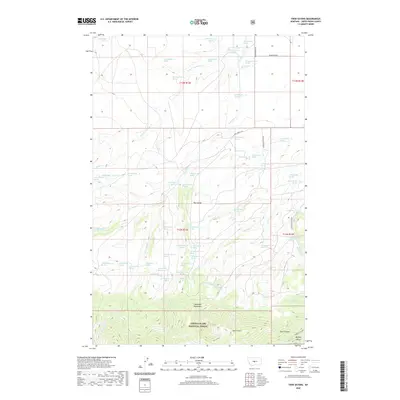
2020 Map of Twin Sisters
USGS Topo · Published 2020About this map
The Little Belt Mountains dominate the southern portion of this Montana landscape, where the Lewis & Clark National Forest encompasses the prominent peaks of the Twin Sisters. The terrain is defined by a series of steep drainages and canyons, most notably Buffalo Canyon and the shadows of Dark Canyon in the southeast. North of the forest boundary, the land transitions into an area of significant grazing and ranching potential, characterized by the broad Big Coulee and the branching waters of Antelope Cr. A dense network of springs, such as 13N13E19AC__01 Spring and dozens of others, provides essential water sources for livestock and wildlife across this arid high-country environment. Rural access is maintained via unpaved routes like New Liberty Rd and Wagon Wheel Rd, which connect remote holdings to the larger region.
Find a feature on this map
69 named features on this map. Tap any name to fly to it.
Don’t see what you’re looking for? This feature index may not catch every label — zoom into the map to look around manually.
Map Details
Editions of this 2020 Twin Sisters Map
This is the sole edition of this map. No revisions or reprints were ever made.
Other maps of this area

1886 · Little Belt Mts.
USGS Topo · 1:250,000

1889 · Big Snowy Mountain
USGS Topo · 1:250,000

1893 · Big Snowy Mountain
USGS Topo · 1:250,000

1894 · Little Belt Mts.
USGS Topo · 1:250,000

1897 · Little Belt Mts.
USGS Topo · 1:250,000

1898 · Little Belt Mts.
USGS Topo · 1:250,000

1902 · Little Belt Mts.
USGS Topo · 1:250,000

1948 · White Sulphur Springs
USGS Topo · 1:250,000

1954 · Roundup
USGS Topo · 1:250,000

1958 · Roundup
USGS Topo · 1:250,000