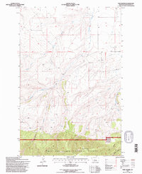
1995 Map of Twin Sisters
USGS Topo · Published 1997About this map
The Lewis and Clark National Forest defines the southern portion of this landscape, where the Judith Ranger District National Forest Boundary marks the transition from open drainage basins into protected forest land. This 1995 revision, based on surveys dating back to 1968, highlights the rugged topography of the Twin Sisters and the intricate network of canyons and coulees that shape the regional hydrology. The map identifies the headwaters and seasonal flows of Antelope Creek and its tributary, West Fork Antelope Creek, alongside the deep incisions of Dark Canyon and Buffalo Canyon. A solitary Well is noted near a basin, suggesting limited industrial or agricultural activity in an area largely dominated by the natural drainage patterns of Big Coulee and West Buffalo Creek. This sheet serves as a clear record of land use and forest management boundaries in the mid-1990s Montana wilderness.
Find a feature on this map
15 named features on this map. Tap any name to fly to it.
Don’t see what you’re looking for? This feature index may not catch every label — zoom into the map to look around manually.
Map Details
Editions of this 1995 Twin Sisters Map
This is the sole edition of this map. No revisions or reprints were ever made.
Other maps of this area

1886 · Little Belt Mts.
USGS Topo · 1:250,000

1889 · Big Snowy Mountain
USGS Topo · 1:250,000

1893 · Big Snowy Mountain
USGS Topo · 1:250,000

1894 · Little Belt Mts.
USGS Topo · 1:250,000

1897 · Little Belt Mts.
USGS Topo · 1:250,000

1898 · Little Belt Mts.
USGS Topo · 1:250,000

1902 · Little Belt Mts.
USGS Topo · 1:250,000

1948 · White Sulphur Springs
USGS Topo · 1:250,000

1954 · Roundup
USGS Topo · 1:250,000

1958 · Roundup
USGS Topo · 1:250,000