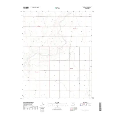
2019 Map of Two Butte Springs
USGS Topo · Published 2019About this map
Two Butte Springs emerges as a prominent water source within the drainage of Two Butte Creek in this portion of Prowers County. The landscape is defined by the strict geometry of the Public Land Survey System, with the land divided into townships such as t25s r43w and t26s r42w. This grid-based organization is mirrored by a functional network of section-line roads, including Co RD S and Co RD 32, which facilitate movement across the agricultural and ranching terrain. In the southern reaches, Dry Cr cuts across the plains near the junction of Co RD 34 and Co RD K. The inclusion of Rice Blvd suggests a local family name preserved in the naming of rural infrastructure, providing a specific point of interest for those tracing the history of local land ownership and the evolution of the county road system.
Find a feature on this map
22 named features on this map. Tap any name to fly to it.
Don’t see what you’re looking for? This feature index may not catch every label — zoom into the map to look around manually.
Map Details
Editions of this 2019 Two Butte Springs Map
This is the sole edition of this map. No revisions or reprints were ever made.
Other maps of this area

1891 · Albany
USGS Topo · 1:125,000

1893 · Albany
USGS Topo · 1:125,000

1955 · La Junta
USGS Topo · 1:250,000

1958 · La Junta
USGS Topo · 1:250,000
1966 · Durkee Creek NE
USGS Topo · 1:24,000
1966 · Two Butte Springs
USGS Topo · 1:24,000
1966 · Durkee Creek NW
USGS Topo · 1:24,000
1966 · Durkee Creek SE
USGS Topo · 1:24,000

1968 · La Junta
USGS Topo · 1:250,000
1968 · North Plum Creek NE
USGS Topo · 1:24,000