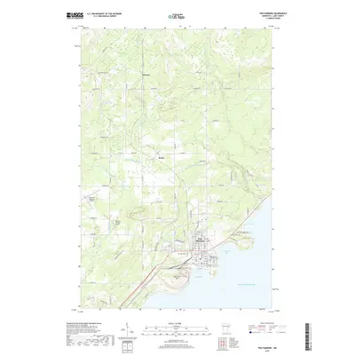
2019 Map of Two Harbors
USGS Topo · Published 2019About this map
Lake Superior dominates the southeastern edge of this survey, where the protected waters of Agate Bay and Burlington Bay meet the shoreline of Two Harbors. This maritime landscape is defined by its coastal infrastructure and the descent of northern tributaries toward the lake. The terrain transitions from the elevations of Pork City Hill down to the harbor, which serves as a focal point for the surrounding settlements of Waldo and Stewart. Genealogists will find the locations of Lakeview Cem and Holy Spirit Catholic Cem near the town center, while those interested in local transportation can trace the routes of the Alger Grade and Old Drummond Rd. The map also captures the path of several watercourses, including the Stewart River and Knife River, which carve through the Lake County interior before emptying into the bay.
Find a feature on this map
67 named features on this map. Tap any name to fly to it.
Don’t see what you’re looking for? This feature index may not catch every label — zoom into the map to look around manually.
Map Details
Editions of this 2019 Two Harbors Map
This is the sole edition of this map. No revisions or reprints were ever made.
Other maps of this area

1953 · Knife River
USGS Topo · 1:24,000

1953 · Ashland
USGS Topo · 1:250,000

1954 · Mc Carthy Creek
USGS Topo · 1:24,000

1954 · Two Harbors
USGS Topo · 1:250,000

1956 · King Lake
USGS Topo · 1:24,000

1957 · Two Harbors
USGS Topo · 1:250,000

1957 · Two Harbors
USGS Topo · 1:62,500

1957 · Two Harbors
USGS Topo · 1:24,000

1957 · Two Harbors NE
USGS Topo · 1:24,000

1957 · Castle Danger
USGS Topo · 1:24,000