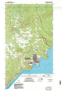
1992 Map of Two Harbors
USGS Topo · Published 1995About this map
The industrial and maritime hub of Two Harbors anchors this Lake Superior coastline, where the grid of the city meets the natural indentations of Agate Bay and Burlington Bay. A prominent Lighthouse stands at the harbor's entrance, signaling the significance of this port for shipping and regional trade. The landscape inland is shaped by water, with the Stewart River and Knife River systems draining toward the lake, while small settlements like Waldo and Stewart mark the paths of transport lines moving away from the shore.
Find a feature on this map
25 named features on this map. Tap any name to fly to it.
Don’t see what you’re looking for? This feature index may not catch every label — zoom into the map to look around manually.
Map Details
Editions of this 1992 Two Harbors Map
This is the sole edition of this map. No revisions or reprints were ever made.
Other maps of this area

1953 · Knife River
USGS Topo · 1:24,000

1953 · Ashland
USGS Topo · 1:250,000

1954 · Mc Carthy Creek
USGS Topo · 1:24,000

1954 · Two Harbors
USGS Topo · 1:250,000

1956 · King Lake
USGS Topo · 1:24,000

1957 · Two Harbors
USGS Topo · 1:250,000

1957 · Two Harbors
USGS Topo · 1:62,500

1957 · Two Harbors
USGS Topo · 1:24,000

1957 · Two Harbors NE
USGS Topo · 1:24,000

1957 · Castle Danger
USGS Topo · 1:24,000