1985 Map of Two Tips
USGS Topo · Published 1985About this map
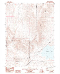
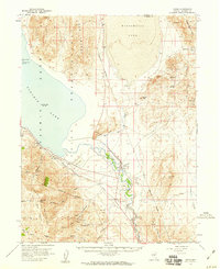
Historical transit corridors through the Great Basin dominate this 1985 survey, showing the overlap of 19th-century migration routes with modern infrastructure. The California Trail and Old Emigrant Road are clearly marked as they traverse the arid Fortymile Desert, a notoriously difficult stretch for pioneers. These historical paths skirt the southeastern edge of the Truckee Range and the high point of Two Tips, leading toward the Fernley Sink. The landscape is a study in land management and utility, featuring the eastern boundary of the Pyramid Lake Indian Reservation alongside the Fernley Wildlife Management Area. Evidence of modern energy and resource extraction appears through a prominent transmission line with a Steel Tower and local industrial sites like a Gravel Pit, contrasting with the primitive terrain of Little Valley and The Gooseneck.
Find a feature on this map
21 named features on this map. Tap any name to fly to it.
Don’t see what you’re looking for? This feature index may not catch every label — zoom into the map to look around manually.
Map Details
Editions of this 1985 Two Tips Map
This is the sole edition of this map. No revisions or reprints were ever made.
Other maps of this area

1890 · Wadsworth
USGS Topo · 1:125,000

1892 · Wadsworth
USGS Topo · 1:125,000

1894 · Wadsworth
USGS Topo · 1:125,000
1957 · Fireball Ridge
USGS Topo · 1:62,500
1957 · Two Tips
USGS Topo · 1:62,500
1957 · Wadsworth
USGS Topo · 1:62,500
1957 · Nixon
USGS Topo · 1:62,500

1957 · Reno
USGS Topo · 1:250,000

1959 · Reno
USGS Topo · 1:250,000

1960 · Reno
USGS Topo · 1:250,000