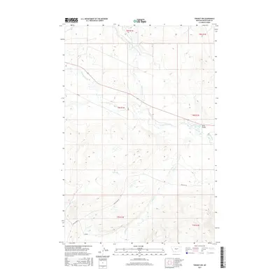
2017 Map of Twodot NW
USGS Topo · Published 2017About this map
The Musselshell River winds through this central Montana landscape, defining the character of the river valley as it transitions between the High Plains and the foothills. In this 2017 study, the intricate water management of the region is evident through the Twodot Canal, which diverts water alongside the river and Willis Coulee. The terrain is deeply grooved by tributaries such as Daisy Dean Cr, Little Elk Cr, and Miller Cr, reflecting a landscape dominated by grazing and water rights. This survey demonstrates the persistence of the Public Land Survey System, with the section lines of Townships 7, 8, and 9 North meticulously preserved. Grounded in the rural heart of Wheatland County, the map provides a precise record of ranch-access routes like Miller Crk Rd and the vast open sections that have characterized this cattle-ranching territory for generations.
Find a feature on this map
13 named features on this map. Tap any name to fly to it.
Don’t see what you’re looking for? This feature index may not catch every label — zoom into the map to look around manually.
Map Details
Editions of this 2017 Twodot NW Map
This is the sole edition of this map. No revisions or reprints were ever made.
Other maps of this area

1886 · Little Belt Mts.
USGS Topo · 1:250,000

1894 · Little Belt Mts.
USGS Topo · 1:250,000

1897 · Little Belt Mts.
USGS Topo · 1:250,000

1898 · Little Belt Mts.
USGS Topo · 1:250,000

1902 · Little Belt Mts.
USGS Topo · 1:250,000

1948 · White Sulphur Springs
USGS Topo · 1:250,000

1958 · White Sulphur Springs
USGS Topo · 1:250,000

1961 · White Sulphur Springs
USGS Topo · 1:250,000

1965 · White Sulphur Springs
USGS Topo · 1:250,000
1972 · Lebo Lake
USGS Topo · 1:24,000