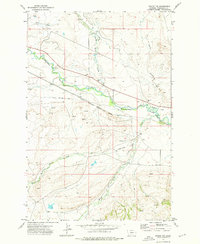
1972 Map of Twodot NW
USGS Topo · Published 1976About this map
The Musselshell River winds through this central Montana landscape, defining a corridor of early transportation and irrigation. The Chicago Milwaukee St Paul and Pacific railroad follows the river valley, paralleled in several sections by an Old Railroad Grade that speaks to earlier alignments or abandoned tracks. Near the center of the sheet, the Moore Ranch marks the sparse settlement pattern typical of Wheatland County, where large landholdings are punctuated by a network of seasonal water sources such as Daisy Dean Creek and Little Elk Creek.
Find a feature on this map
18 named features on this map. Tap any name to fly to it.
Don’t see what you’re looking for? This feature index may not catch every label — zoom into the map to look around manually.
Map Details
Editions of this 1972 Twodot NW Map
This is the sole edition of this map. No revisions or reprints were ever made.
Other maps of this area

1886 · Little Belt Mts.
USGS Topo · 1:250,000

1894 · Little Belt Mts.
USGS Topo · 1:250,000

1897 · Little Belt Mts.
USGS Topo · 1:250,000

1898 · Little Belt Mts.
USGS Topo · 1:250,000

1902 · Little Belt Mts.
USGS Topo · 1:250,000

1948 · White Sulphur Springs
USGS Topo · 1:250,000

1958 · White Sulphur Springs
USGS Topo · 1:250,000

1961 · White Sulphur Springs
USGS Topo · 1:250,000

1965 · White Sulphur Springs
USGS Topo · 1:250,000
1972 · Lebo Lake
USGS Topo · 1:24,000