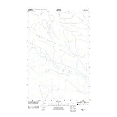
2011 Map of Tyler
USGS Topo · Published 2011About this map
The small settlement of Tyler sits along the western edge of this central Montana landscape, where the prairie is defined by a dense network of coulees and drainage systems. This 2011 survey shows a rural environment centered on the Tyler Cemetery and the meandering path of Flatwillow Creek. The hydrology of the area is particularly detailed, tracing the courses of Elk Creek, Spring Creek, and Durfee Creek as they carve through the terrain. A unique point of interest is the Muppet Dam, located south of Upper Flatwillow Rd. The map illustrates a sparse but persistent network of local roads that connect these isolated water sources and homestead sites, reflecting the enduring ranching and agricultural character of Fergus County in the early 21st century.
Find a feature on this map
11 named features on this map. Tap any name to fly to it.
Don’t see what you’re looking for? This feature index may not catch every label — zoom into the map to look around manually.
Map Details
Editions of this 2011 Tyler Map
This is the sole edition of this map. No revisions or reprints were ever made.
Other maps of this area

1954 · Roundup
USGS Topo · 1:250,000

1958 · Roundup
USGS Topo · 1:250,000

1986 · Tyler
USGS Topo · 1:24,000

1986 · Devils Hole Lake
USGS Topo · 1:24,000

1986 · Pender Coulee
USGS Topo · 1:24,000

1986 · Pike Creek Hills West
USGS Topo · 1:24,000

1986 · Lake Mason NW
USGS Topo · 1:24,000

1986 · Milk Springs
USGS Topo · 1:24,000
1986 · Bald Butte
USGS Topo · 1:24,000
1986 · Becket NE
USGS Topo · 1:24,000