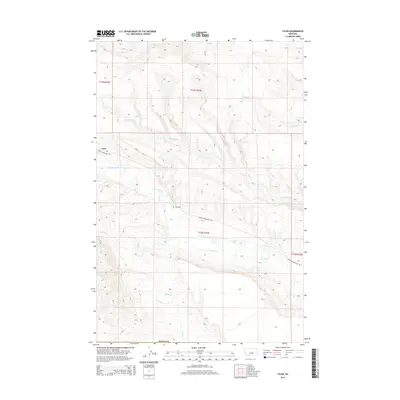
2014 Map of Tyler
USGS Topo · Published 2014About this map
The small settlement of Tyler sits along Upper Flatwillow Rd in this 2014 survey of Fergus County. The local landscape is defined by a dense network of watercourses, including Flatwillow Cr and Durfee Cr, which carve through the plains. For genealogists and local historians, the Tyler Cem provides a specific point of interest near the town site. The map captures a moment in time when this rural area remained largely defined by its natural hydrology, with Spring Cr, Elk Cr, and Pike Cr draining the northern reaches. The survey detail illustrates how the regional road network conforms to the varied drainage patterns and ridges of central Montana, reflecting the long-standing agricultural and ranching footprint of the community.
Find a feature on this map
15 named features on this map. Tap any name to fly to it.
Don’t see what you’re looking for? This feature index may not catch every label — zoom into the map to look around manually.
Map Details
Editions of this 2014 Tyler Map
This is the sole edition of this map. No revisions or reprints were ever made.
Other maps of this area

1954 · Roundup
USGS Topo · 1:250,000

1958 · Roundup
USGS Topo · 1:250,000

1986 · Tyler
USGS Topo · 1:24,000

1986 · Devils Hole Lake
USGS Topo · 1:24,000

1986 · Pender Coulee
USGS Topo · 1:24,000

1986 · Pike Creek Hills West
USGS Topo · 1:24,000

1986 · Lake Mason NW
USGS Topo · 1:24,000

1986 · Milk Springs
USGS Topo · 1:24,000
1986 · Bald Butte
USGS Topo · 1:24,000
1986 · Becket NE
USGS Topo · 1:24,000