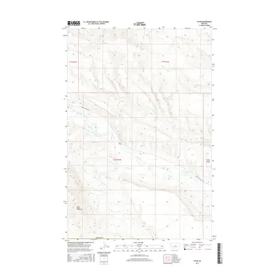
2017 Map of Tyler
USGS Topo · Published 2017About this map
The Little Snowy Mountains dominate the southwestern corner of this Fergus County landscape, where the terrain drops away into a complex network of drainage basins. Central to the area's local history is the Tyler Cem, a solitary landmark situated north of Flatwillow Cr that speaks to the early settlement of this high plains region. The map captures a detailed view of the local hydrology, tracing the paths of Durfee Cr and Jones Cr as they cut through the section lines of Township 12 North.
Find a feature on this map
15 named features on this map. Tap any name to fly to it.
Don’t see what you’re looking for? This feature index may not catch every label — zoom into the map to look around manually.
Map Details
Editions of this 2017 Tyler Map
This is the sole edition of this map. No revisions or reprints were ever made.
Other maps of this area

1954 · Roundup
USGS Topo · 1:250,000

1958 · Roundup
USGS Topo · 1:250,000

1986 · Tyler
USGS Topo · 1:24,000

1986 · Devils Hole Lake
USGS Topo · 1:24,000

1986 · Pender Coulee
USGS Topo · 1:24,000

1986 · Pike Creek Hills West
USGS Topo · 1:24,000

1986 · Lake Mason NW
USGS Topo · 1:24,000

1986 · Milk Springs
USGS Topo · 1:24,000
1986 · Bald Butte
USGS Topo · 1:24,000
1986 · Becket NE
USGS Topo · 1:24,000