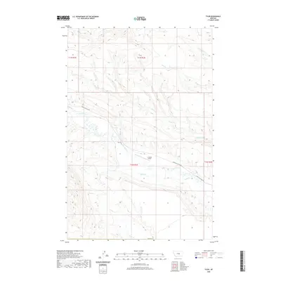
2020 Map of Tyler
USGS Topo · Published 2020About this map
The settlement of Tyler anchors this Central Montana landscape, reflecting the ranching heritage of Fergus County at the start of the 2020s. This drainage-rich territory is defined by the convergence of several named waterways, including Flatwillow Creek and Durfee Creek, which carve through the high plains. A clear sense of the local community's footprint is visible at the Tyler Cemetery, while the presence of the 16 Ranch Airport highlights the continued importance of private aviation in navigating these expansive western distances. Access through the region is primary facilitated by Upper Flatwillow Road, which traces the contours of the namesake creek. The map provides a detailed look at the land partitions and natural drainages like Spring Creek and Buck Creek that have dictated settlement patterns and land use in this part of the state for generations.
Find a feature on this map
16 named features on this map. Tap any name to fly to it.
Don’t see what you’re looking for? This feature index may not catch every label — zoom into the map to look around manually.
Map Details
Editions of this 2020 Tyler Map
This is the sole edition of this map. No revisions or reprints were ever made.
Other maps of this area

1954 · Roundup
USGS Topo · 1:250,000

1958 · Roundup
USGS Topo · 1:250,000

1986 · Tyler
USGS Topo · 1:24,000

1986 · Devils Hole Lake
USGS Topo · 1:24,000

1986 · Pender Coulee
USGS Topo · 1:24,000

1986 · Pike Creek Hills West
USGS Topo · 1:24,000

1986 · Lake Mason NW
USGS Topo · 1:24,000

1986 · Milk Springs
USGS Topo · 1:24,000
1986 · Bald Butte
USGS Topo · 1:24,000
1986 · Becket NE
USGS Topo · 1:24,000