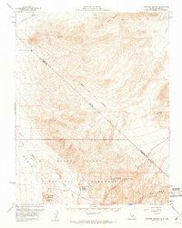
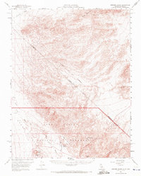
1957 Map of Ubehebe Crater
USGS Topo · Published 1960About this map
Death Valley National Monument reveals a stark desert landscape defined by volcanic activity and the isolated outposts of the northern Mojave. The dramatic Ubehebe Crater and its smaller neighbor, Little Hebe Crater, dominate the southwestern terrain, serving as primary geological landmarks. Near the Grapevine Mountains, the presence of Scottys Castle and Scottys Ranch indicates the mid-century development of this arid region, supported by water sources like Grapevine Springs. Historical boundaries are prominent, including the Von Schmidt Line (1872) which traces an earlier survey of the Nevada California border. To the north, Gold Mountain is marked by numerous mining features such as a Shaft, Tunnels, and several Prospects, illustrating the era's persistent search for mineral wealth amidst the alluvial fans of Oriental Wash.
Find a feature on this map
29 named features on this map. Tap any name to fly to it.
Don’t see what you’re looking for? This feature index may not catch every label — zoom into the map to look around manually.
Map Details
Editions of this 1957 Ubehebe Crater Map
2 editions found
Other maps of this area

1908 · Lida
USGS Topo · 1:250,000

1908 · Ballarat
USGS Topo · 1:250,000

1913 · Lida
USGS Topo · 1:250,000

1913 · Ballarat
USGS Topo · 1:250,000

1948 · Death Valley
USGS Topo · 1:250,000

1954 · Death Valley
USGS Topo · 1:250,000

1954 · Goldfield
USGS Topo · 1:250,000

1955 · Goldfield
USGS Topo · 1:250,000

1956 · Death Valley
USGS Topo · 1:250,000
1957 · Death Valley
USGS Topo · 1:250,000