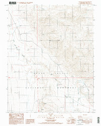
1988 Map of Ubehebe Crater
USGS Topo · Published 1988About this map
Ubehebe Crater and the nearby Little Hebe Crater dominate the southern portion of this desert landscape, revealing the volcanic activity that shaped this part of Death Valley National Monument. Mapping of this terrain in the late 1980s reveals a network of seasonal watercourses, including the wide Death Valley Wash and the more defined Little Grapevine Creek feeding toward the Grapevine Springs. Aside from a single Gate and a lone Borrow Pit, the land remains largely undeveloped, defined by the stark transition from valley floor to rising alluvial fans. The topographical data provided by the Nos/Noaa and the Geological Survey captures the precise contours of the maars and volcanic fields during a period before the monument’s redesignation as a National Park.
Find a feature on this map
13 named features on this map. Tap any name to fly to it.
Don’t see what you’re looking for? This feature index may not catch every label — zoom into the map to look around manually.
Map Details
Editions of this 1988 Ubehebe Crater Map
2 editions found
Other maps of this area

1908 · Lida
USGS Topo · 1:250,000

1908 · Ballarat
USGS Topo · 1:250,000

1913 · Lida
USGS Topo · 1:250,000

1913 · Ballarat
USGS Topo · 1:250,000

1948 · Death Valley
USGS Topo · 1:250,000

1954 · Death Valley
USGS Topo · 1:250,000

1954 · Goldfield
USGS Topo · 1:250,000

1955 · Goldfield
USGS Topo · 1:250,000

1956 · Death Valley
USGS Topo · 1:250,000

1957 · Death Valley
USGS Topo · 1:250,000