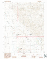
1988 Map of Ubehebe Crater
USGS Topo · Published 1988About this map
Ubehebe Crater and its smaller neighbor Little Hebe Crater define this 1980s landscape within the northern boundary of Death Valley National Monument. The terrain is shaped by volcanic activity and ephemeral water drainage, with the prominent Death Valley Wash cutting through the western section of the quadrangle. In the eastern reaches, Little Grapevine Creek provides a rare point of named drainage in this arid environment. This provisional survey captures the area at a time when road access remained limited to improved and unimproved tracks, preserving the geological integrity of these massive volcanic pits. Researchers can trace the exact relationship between the primary crater floor and the surrounding ridgelines that characterize this portion of Inyo County.
Find a feature on this map
8 named features on this map. Tap any name to fly to it.
Don’t see what you’re looking for? This feature index may not catch every label — zoom into the map to look around manually.
Map Details
Editions of this 1988 Ubehebe Crater Map
2 editions found
Other maps of this area

1908 · Lida
USGS Topo · 1:250,000

1908 · Ballarat
USGS Topo · 1:250,000

1913 · Lida
USGS Topo · 1:250,000

1913 · Ballarat
USGS Topo · 1:250,000

1948 · Death Valley
USGS Topo · 1:250,000

1954 · Death Valley
USGS Topo · 1:250,000

1954 · Goldfield
USGS Topo · 1:250,000

1955 · Goldfield
USGS Topo · 1:250,000

1956 · Death Valley
USGS Topo · 1:250,000

1957 · Death Valley
USGS Topo · 1:250,000