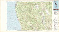
1981 Map of Ukiah
USGS Topo · Published 1981About this map
The coastal lumber towns and inland valleys of Mendocino County are documented here in the early 1980s, revealing a landscape defined by its timber heritage and emerging agricultural corridors. The California Western Railroad winds through the dense Jackson State Forest, connecting the coastal port of Fort Bragg with the interior rail hub at Willits. In the east, the Northwestern Pacific line follows the Russian River through the heart of Ukiah, passing the newly formed Lake Mendocino and the agricultural reaches of Potter Valley. This period shows the transition of the Anderson Valley through Philo and Boonville as a distinct rural enclave. Along the shoreline, several state parks including Mendocino Headlands State Park and Van Damme Beach State Park preserve the character of the rugged Pacific front near the historic settlement of Mendocino.
Find a feature on this map
49 named features on this map. Tap any name to fly to it.
Don’t see what you’re looking for? This feature index may not catch every label — zoom into the map to look around manually.
Map Details
Editions of this 1981 Ukiah Map
3 editions found
Other maps of this area

1920 · Glenblair
USGS Topo · 1:62,500

1920 · Ukiah
USGS Topo · 1:62,500

1920 · Fort Bragg
USGS Topo · 1:62,500

1921 · Kelseyville
USGS Topo · 1:62,500

1921 · Westport
USGS Topo · 1:62,500

1921 · Branscomb
USGS Topo · 1:62,500

1922 · Willits
USGS Topo · 1:62,500

1922 · Hullville
USGS Topo · 1:62,500

1929 · Eden Valley
USGS Topo · 1:62,500

1938 · Lakeport
USGS Topo · 1:62,500