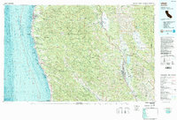
1981 Map of Ukiah
USGS Topo · Published 1987About this map
Jackson State Forest and the Mendocino Range dominate this 1980s landscape, illustrating the complex intersection of the Pacific coastline and the interior valleys. The timber and transport legacy is visible through the route of the California Western railroad, which winds through isolated settlements like Northspur and Irmulco toward the coast at Fort Bragg. This map captures the region before the modern expansion of its viticulture and tourism sectors, showing the established layouts of Ukiah, Willits, and the Anderson Valley communities of Philo and Boonville. Along the shore, a series of protected lands, including Russian Gulch State Park and the Mendocino Woodlands State Recreation Area, highlight the early preservation of the redwood coast. To the east, Lake Mendocino and the Maacamas Mountains define the transition toward the interior counties.
Find a feature on this map
84 named features on this map. Tap any name to fly to it.
Don’t see what you’re looking for? This feature index may not catch every label — zoom into the map to look around manually.
Map Details
Editions of this 1981 Ukiah Map
3 editions found
Other maps of this area

1920 · Glenblair
USGS Topo · 1:62,500

1920 · Ukiah
USGS Topo · 1:62,500

1920 · Fort Bragg
USGS Topo · 1:62,500

1921 · Kelseyville
USGS Topo · 1:62,500

1921 · Westport
USGS Topo · 1:62,500

1921 · Branscomb
USGS Topo · 1:62,500

1922 · Willits
USGS Topo · 1:62,500

1922 · Hullville
USGS Topo · 1:62,500

1929 · Eden Valley
USGS Topo · 1:62,500

1938 · Lakeport
USGS Topo · 1:62,500