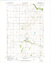
1966 Map of Ulen SW
USGS Topo · Published 1967About this map
The South Branch Wild Rice River meanders through the northeast corner of this Clay County landscape, marking a natural contrast to the heavily managed agricultural drainage system to the south. In the mid-1960s, this region was defined by an extensive network of waterways including County Ditch No 45, County Ditch No 10, and Ditch No 79, which speak to the area's transition into productive farmland. Central to the map is the Felton State Wildlife Management Area, a preserved space amid the sectioned townships of Felton, Hagen, Flowing, and Keene. The settlement of Felton sits on the western edge, near the Felton Cem, while numerous Gravel Pits and a Flowing Well indicate the local geological and water resources being utilized during this era.
Find a feature on this map
18 named features on this map. Tap any name to fly to it.
Don’t see what you’re looking for? This feature index may not catch every label — zoom into the map to look around manually.
Map Details
Editions of this 1966 Ulen SW Map
This is the sole edition of this map. No revisions or reprints were ever made.
Other maps of this area

1895 · Fargo
USGS Topo · 1:125,000

1897 · Fargo
USGS Topo · 1:125,000

1918 · Ulen
USGS Topo · 1:62,500

1919 · Hawley
USGS Topo · 1:62,500

1952 · Grand Forks
USGS Topo · 1:250,000

1953 · Fargo
USGS Topo · 1:250,000

1956 · Fargo
USGS Topo · 1:250,000

1956 · Grand Forks
USGS Topo · 1:250,000
1964 · Glyndon North
USGS Topo · 1:24,000

1965 · Syre
USGS Topo · 1:24,000