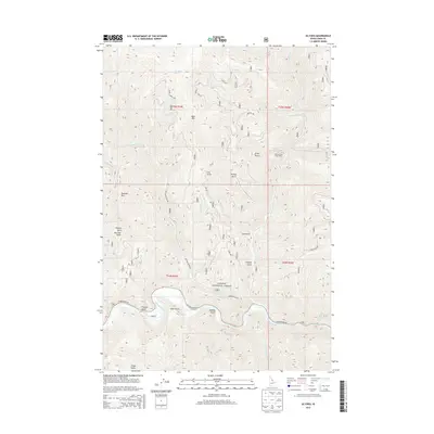
2013 Map of Ulysses
USGS Topo · Published 2013About this map
Salmon National Forest defines the steep topography of this Idaho landscape, where the Salmon River carves a deep, winding path across the southern sections. This 2013 survey illustrates the remote character of Lemhi County, centered on the confluence of several drainages including Squaw Creek and Indian Creek. Human activity is concentrated along the river corridor and major forest routes, notably the Salmon River Rd and Squaw Creek Rd. Landmarks like the Indian Creek Guest Ranch and the small settlement at Cadigan provide fixed points for local history, while the map’s detailed terrain labels—from Dutchler Mtn to the many named gulches like Hale Gulch and China Gulch—offer a precise record of family-named landmarks and old access points in the backcountry.
Find a feature on this map
32 named features on this map. Tap any name to fly to it.
Don’t see what you’re looking for? This feature index may not catch every label — zoom into the map to look around manually.
Map Details
Editions of this 2013 Ulysses Map
This is the sole edition of this map. No revisions or reprints were ever made.
Other maps of this area

1956 · Elk City
USGS Topo · 1:250,000

1960 · Elk City
USGS Topo · 1:250,000

1960 · Painted Rocks Lake
USGS Topo · 1:62,500

1960 · Ulysses Mtn
USGS Topo · 1:62,500

1960 · Shoup
USGS Topo · 1:62,500

1960 · Piquett Mountain
USGS Topo · 1:62,500

1982 · Bighorn Crags
USGS Topo · 1:100,000
1991 · Henderson Ridge
USGS Topo · 1:24,000
1991 · Ulysses Mountain
USGS Topo · 1:24,000
1991 · Allan Mountain
USGS Topo · 1:24,000