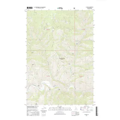
2017 Map of Ulysses
USGS Topo · Published 2017About this map
Ulysses sits within a complex network of steep drainages and mountain peaks in this Lemhi County landscape. The topography is dominated by the Salmon River corridor, which flows through the southern portion of the quadrangle, flanked by numerous steep-walled canyons including Hale Gulch and Sawlog Gulch. High-elevation landmarks such as Bald Mtn and Dutchler Mtn rise above the Salmon National Forest, with the later overlooking Dutchler Basin. The map documents an intricate system of remote forest access routes like Squaw Creek Rd and Indian Creek Rd, which follow the primary watercourses of Squaw Creek and Indian Cr. Local water sources are noted throughout the high country, including Marlin Spring and Coyote Spring, illustrating the critical role of dispersed water points in this arid, timbered environment.
Find a feature on this map
43 named features on this map. Tap any name to fly to it.
Don’t see what you’re looking for? This feature index may not catch every label — zoom into the map to look around manually.
Map Details
Editions of this 2017 Ulysses Map
This is the sole edition of this map. No revisions or reprints were ever made.
Other maps of this area

1956 · Elk City
USGS Topo · 1:250,000

1960 · Elk City
USGS Topo · 1:250,000

1960 · Painted Rocks Lake
USGS Topo · 1:62,500

1960 · Ulysses Mtn
USGS Topo · 1:62,500

1960 · Shoup
USGS Topo · 1:62,500

1960 · Piquett Mountain
USGS Topo · 1:62,500

1982 · Bighorn Crags
USGS Topo · 1:100,000
1991 · Henderson Ridge
USGS Topo · 1:24,000
1991 · Ulysses Mountain
USGS Topo · 1:24,000
1991 · Allan Mountain
USGS Topo · 1:24,000