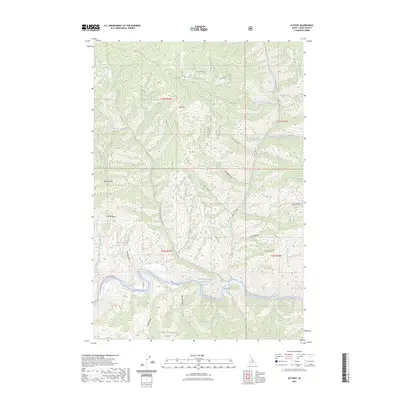
2023 Map of Ulysses
USGS Topo · Published 2023About this map
The Salmon Wild and Scenic River carves a deep path through the heart of the Salmon National Forest in this 2023 survey. This drainage system is defined by its complex network of gulches and creeks, including Crystal Gulch and East Boulder Creek, which feed into the main river channel. High elevation landmarks such as Bold Mtn and Dutcher Mtn overlook the steep terrain of Dutcher Basin. The infrastructure of the area is primarily composed of forest service routes like the Salmon River Rd and Indian Creek Rd, which provide access to remote water sources like Porcupine Spring and Coyote Spring. The map documents traditional Indigenous place names alongside modern designations, including Bia-Pa'i-Naokwaide and Dawa-Agai Naokwaide, reflecting the enduring cultural geography of this Lemhi County landscape.
Find a feature on this map
39 named features on this map. Tap any name to fly to it.
Don’t see what you’re looking for? This feature index may not catch every label — zoom into the map to look around manually.
Map Details
Editions of this 2023 Ulysses Map
This is the sole edition of this map. No revisions or reprints were ever made.
Other maps of this area

1956 · Elk City
USGS Topo · 1:250,000

1960 · Elk City
USGS Topo · 1:250,000

1960 · Painted Rocks Lake
USGS Topo · 1:62,500

1960 · Ulysses Mtn
USGS Topo · 1:62,500

1960 · Shoup
USGS Topo · 1:62,500

1960 · Piquett Mountain
USGS Topo · 1:62,500

1982 · Bighorn Crags
USGS Topo · 1:100,000
1991 · Henderson Ridge
USGS Topo · 1:24,000
1991 · Ulysses Mountain
USGS Topo · 1:24,000
1991 · Allan Mountain
USGS Topo · 1:24,000