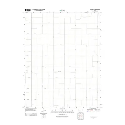
2012 Map of Ulysses NE
USGS Topo · Published 2012About this map
Lakin Draw meanders through this agricultural landscape in Sherman Township, defining the primary drainage pattern across an otherwise orderly section of the High Plains. This 2012 survey by the U.S. Geological Survey illustrates the rigorous section-line grid of Grant County, where the road network follows a strict alphanumeric nomenclature. Major north-south arteries including N Road K, N Stubbs Rd, and N Road P intersect with east-west routes such as E Road 2 and W Road 8 to facilitate regional commerce and access to the surrounding fields. The northern edge of the map is defined by Co Line Rd, marking the administrative boundary with the adjacent county. This map is a clear record of modern Kansas land division, showing how contemporary infrastructure and transport remain tied to the historical township and range system.
Find a feature on this map
25 named features on this map. Tap any name to fly to it.
Don’t see what you’re looking for? This feature index may not catch every label — zoom into the map to look around manually.
Map Details
Editions of this 2012 Ulysses NE Map
This is the sole edition of this map. No revisions or reprints were ever made.
Other maps of this area

1891 · Larned
USGS Topo · 1:125,000

1900 · Lakin
USGS Topo · 1:125,000

1955 · Dodge City
USGS Topo · 1:250,000

1958 · Dodge City
USGS Topo · 1:250,000

1959 · Dodge City
USGS Topo · 1:250,000

1959 · Ulysses NW
USGS Topo · 1:24,000

1959 · Ulysses
USGS Topo · 1:24,000

1959 · Ulysses NE
USGS Topo · 1:24,000

1959 · Hickok NW
USGS Topo · 1:24,000
1959 · Ulysses SW
USGS Topo · 1:24,000