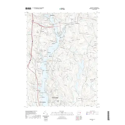
2021 Map of Uncasville
USGS Topo · Published 2021About this map
The Thames River corridor south of Norwich serves as the central artery for this part of southeastern Connecticut, where maritime geography and ancestral sites converge. The landscape is defined by a sequence of riverfront settlements including Uncasville, Mohegan, and Gales Ferry, each tied to the tidal waters and the P & W RR line. Notable cultural landmarks like the Fort Shantok Indian Burying Ground near Crow Hill and the massive glacial erratic Cochegan Rock reflect the deep indigenous and geological history of the Mohegan territory. To the south, the map details the grounds of Connecticut College and the specialized infrastructure of Conning Towers Nautilus Park. Numerous burial sites, such as Brewster's Neck Cem and Saint Patrick Cem, are scattered across the hills, offering significant detail for those tracing the development of local villages and family estates in the valleys surrounding Haughton Mtn and Avery Hill.
Find a feature on this map
279 named features on this map. Tap any name to fly to it.
Don’t see what you’re looking for? This feature index may not catch every label — zoom into the map to look around manually.
Map Details
Editions of this 2021 Uncasville Map
This is the sole edition of this map. No revisions or reprints were ever made.
Other maps of this area

1889 · Stonington
USGS Topo · 1:62,500

1889 · Moosup
USGS Topo · 1:62,500

1892 · New London
USGS Topo · 1:62,500

1892 · Norwich
USGS Topo · 1:62,500

1893 · Moosup
USGS Topo · 1:62,500

1893 · Stonington
USGS Topo · 1:62,500

1893 · New London
USGS Topo · 1:62,500

1920 · Moosup
USGS Topo · 1:62,500

1921 · New London
USGS Topo · 1:62,500

1921 · Stonington
USGS Topo · 1:62,500