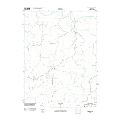
2010 Map of Union City
USGS Topo · Published 2010About this map
Union City and Doylesville anchor this Madison County landscape, where the Kentucky River defines the northern boundary. The terrain is deeply etched by a network of waterways, including the winding Muddy Creek and the East Fork Otter Creek, which historically dictated the placement of early settlements and agricultural tracts. A notable point of river crossing is preserved at Jackson Ferry, while the local economy's historical reliance on water power is signaled by Weddles Mill further east along the creek banks.
Find a feature on this map
39 named features on this map. Tap any name to fly to it.
Don’t see what you’re looking for? This feature index may not catch every label — zoom into the map to look around manually.
Map Details
Editions of this 2010 Union City Map
This is the sole edition of this map. No revisions or reprints were ever made.
Other maps of this area

1892 · Richmond
USGS Topo · 1:125,000

1897 · Richmond
USGS Topo · 1:125,000

1952 · Union City
USGS Topo · 1:24,000

1952 · Palmer
USGS Topo · 1:24,000

1952 · Ford
USGS Topo · 1:24,000

1952 · Winchester
USGS Topo · 1:24,000

1952 · Richmond North
USGS Topo · 1:24,000

1952 · Panola
USGS Topo · 1:24,000
1952 · Hedges
USGS Topo · 1:24,000

1952 · Moberly
USGS Topo · 1:24,000