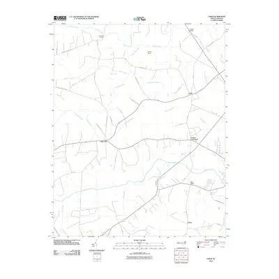
2010 Map of Union
USGS Topo · Published 2010About this map
Saint John and the surrounding rural communities of Hertford County are defined by a network of slow-moving waterways and local crossings at the start of the 21st century. The landscape is dominated by the broad basins of Potecasi Creek and Ahoskie Creek, which carve out distinct landforms like Buffalo Island. Small named settlements such as Union, Fraziers Crossroads, and the curiously named Poor Town are situated along a web of state-maintained roads like NC-1142 and NC-1189, reflecting a long-standing agricultural and residential pattern. Historical transport links are preserved through bridge names like Benthalls Bridge and Knights Bridge, while the presence of locations such as Earleys and Old Tree Swamp suggests a landscape where family history and geographical nomenclature are deeply intertwined.
Find a feature on this map
47 named features on this map. Tap any name to fly to it.
Don’t see what you’re looking for? This feature index may not catch every label — zoom into the map to look around manually.
Map Details
Editions of this 2010 Union Map
This is the sole edition of this map. No revisions or reprints were ever made.
Other maps of this area

1908 · Winton
USGS Topo · 1:62,500

1953 · Norfolk
USGS Topo · 1:250,000

1972 · Aulander
USGS Topo · 1:24,000
1973 · Murfreesboro
USGS Topo · 1:24,000
1973 · Conway
USGS Topo · 1:24,000

1973 · Kelford
USGS Topo · 1:24,000

1977 · Union
USGS Topo · 1:24,000

1977 · Woodland
USGS Topo · 1:24,000

1982 · Powellsville
USGS Topo · 1:24,000
1982 · Winton
USGS Topo · 1:24,000