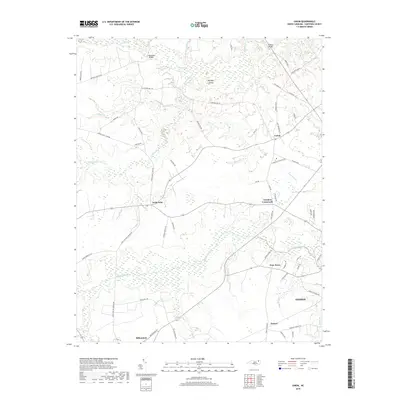
2019 Map of Union
USGS Topo · Published 2019About this map
The coastal plain of Hertford County is defined by its intricate drainage networks and long-standing rural communities. Historically centered around agriculture and timber, the landscape is etched with watercourses such as Ahoskie Creek, Potecasi Cr, and Old Tree Swamp, which shape the placement of historic roadbeds and crossings. Local infrastructure relies on points like Benthalls Bridge and Knights Bridge to navigate the marshy terrain. Small, named hubs like Saint John, Union, and Fraziers Crossroads serve as the primary social and economic anchors for the surrounding farmsteads. The southern edge of the survey transitions into the urban outskirts of Ahoskie, while rural enclaves like Poor Town and Millennium retain their traditional, isolated character. The presence of Buffalo Island within the swampy lowlands illustrates the complex topography that has influenced land use in this part of North Carolina for generations.
Find a feature on this map
66 named features on this map. Tap any name to fly to it.
Don’t see what you’re looking for? This feature index may not catch every label — zoom into the map to look around manually.
Map Details
Editions of this 2019 Union Map
This is the sole edition of this map. No revisions or reprints were ever made.
Other maps of this area

1908 · Winton
USGS Topo · 1:62,500

1953 · Norfolk
USGS Topo · 1:250,000

1972 · Aulander
USGS Topo · 1:24,000
1973 · Murfreesboro
USGS Topo · 1:24,000
1973 · Conway
USGS Topo · 1:24,000

1973 · Kelford
USGS Topo · 1:24,000

1977 · Union
USGS Topo · 1:24,000

1977 · Woodland
USGS Topo · 1:24,000

1982 · Powellsville
USGS Topo · 1:24,000
1982 · Winton
USGS Topo · 1:24,000