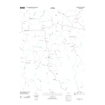
2013 Map of Union Hill
USGS Topo · Published 2013About this map
Union Hill and surrounding rural crossroads define the landscape of this Tennessee and Kentucky border region. The area is characterized by a network of local roads that connect small agricultural settlements and family farms, such as Smith's Poultry Farms and the Running Late Poultry Farm. The drainage pattern is complex, with several branches of Brimstone Cr and Brannon Cr carving through the terrain, punctuated by features like Brays Knob and McCormick Ridge. Numerous unnamed structures are scattered along routes like Gulley Rd and Old Mulkey Rd, suggesting a persistent rural population. Water management is evident in the presence of engineered bodies like Line Creek Lake Number Three B and Lake Site Number Four, which serve the local watershed along the state line.
Find a feature on this map
116 named features on this map. Tap any name to fly to it.
Don’t see what you’re looking for? This feature index may not catch every label — zoom into the map to look around manually.
Map Details
Editions of this 2013 Union Hill Map
This is the sole edition of this map. No revisions or reprints were ever made.
Other maps of this area

1925 · Gainesboro
USGS Topo · 1:62,500

1929 · Gainesboro
USGS Topo · 1:62,500

1929 · Tompkinsville
USGS Topo · 1:62,500

1931 · Red Boiling Springs
USGS Topo · 1:62,500

1932 · Carthage
USGS Topo · 1:62,500

1954 · Gamaliel
USGS Topo · 1:24,000

1954 · Tompkinsville
USGS Topo · 1:24,000
1954 · Vernon
USGS Topo · 1:24,000

1956 · Corbin
USGS Topo · 1:250,000

1958 · Corbin
USGS Topo · 1:250,000