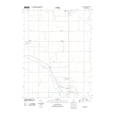
2010 Map of Uniondale
USGS Topo · Published 2010About this map
The Wabash River meanders through the heart of this Wells County landscape, anchoring the northern outskirts of Bluffton. To the north, the terrain is defined by a dense network of agricultural drainage systems, including Eightmile Number Two Ditch, Griffin Ditch, and Hunter Drain, which support the fertile plains between the scattered communities. Small settlements and residential pockets such as Uniondale, Kingsland, and Murray are connected by a grid of rural roads and state routes, reflecting the region's enduring agrarian and residential character. Local history is preserved in sites like Murray Cemetery and Oak Lawn Cemetery, while modern developments like Toll Gate Heights and North Oaks signify more recent suburban growth. This survey captures the transition from the structured street grid of Bluffton to the open drainage-fed farm tracts extending toward Ossian at the northern map edge.
Find a feature on this map
57 named features on this map. Tap any name to fly to it.
Don’t see what you’re looking for? This feature index may not catch every label — zoom into the map to look around manually.
Map Details
Editions of this 2010 Uniondale Map
This is the sole edition of this map. No revisions or reprints were ever made.
Other maps of this area

1953 · Muncie
USGS Topo · 1:250,000

1955 · Markle
USGS Topo · 1:24,000

1956 · Muncie
USGS Topo · 1:250,000
1961 · Zanesville
USGS Topo · 1:24,000

1962 · Poe
USGS Topo · 1:24,000

1962 · Uniondale
USGS Topo · 1:24,000

1962 · Ossian
USGS Topo · 1:24,000

1962 · Liberty Center
USGS Topo · 1:24,000

1962 · Preble
USGS Topo · 1:24,000

1962 · Linn Grove
USGS Topo · 1:24,000