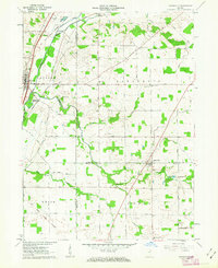
1961 Map of Zanesville
USGS Topo · Published 1963About this map
Little River and the Wabash RR define the northwest corner of this Indiana landscape, where the town of Roanoke sits at a critical junction of transport and early surveying history. The Old Indian Treaty Boundary cuts diagonally through the townships of Jackson and Union, a historical line that still influenced property and field patterns as seen in the 1960s. South of the river, the terrain is shaped by a network of drainage ways like Eightmile Creek and Flat Creek, supporting a rural community tied together by country churches and schools. Local history is recorded in sites like Monson Chapel, Lafayette Central Sch, and several small family burial grounds including Shank Cem and Arick Cem. The town of Zanesville anchors the southern portion of the quadrangle on the border between Allen and Wells counties, showing the established grid of early 1960s roads like Witzgall Road and Yoder Road.
Find a feature on this map
65 named features on this map. Tap any name to fly to it.
Don’t see what you’re looking for? This feature index may not catch every label — zoom into the map to look around manually.
Map Details
Editions of this 1961 Zanesville Map
This is the sole edition of this map. No revisions or reprints were ever made.
Other maps of this area

1952 · Majenica
USGS Topo · 1:24,000

1953 · Fort Wayne
USGS Topo · 1:250,000

1953 · Muncie
USGS Topo · 1:250,000

1955 · Markle
USGS Topo · 1:24,000

1956 · Muncie
USGS Topo · 1:250,000

1956 · Fort Wayne
USGS Topo · 1:250,000

1956 · Fort Wayne West
USGS Topo · 1:24,000

1956 · Huntington
USGS Topo · 1:24,000

1961 · Arcola
USGS Topo · 1:24,000
1961 · Laud
USGS Topo · 1:24,000