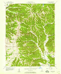
1957 Map of Unionville
USGS Topo · Published 1959About this map
Deeply incised ridges and hollows characterize this portion of Monroe County, much of which is encompassed by the Morgan-Monroe State Forest. The Illinois Central railroad cuts a definitive path through the landscape, serving the community of Unionville and the railroad stop at New Unionville. The presence of numerous Gas Wells throughout the northern sections points to a history of natural resource extraction that coexisted with the region's timber and agricultural heritage.
Find a feature on this map
56 named features on this map. Tap any name to fly to it.
Don’t see what you’re looking for? This feature index may not catch every label — zoom into the map to look around manually.
Map Details
Editions of this 1957 Unionville Map
This is the sole edition of this map. No revisions or reprints were ever made.
Other maps of this area

1908 · Bloomington
USGS Topo · 1:48,000

1910 · Bloomington
USGS Topo · 1:62,500

1942 · Franklin
USGS Topo · 1:125,000

1946 · Belmont
USGS Topo · 1:24,000

1947 · Allens Creek
USGS Topo · 1:24,000

1947 · Unionville
USGS Topo · 1:24,000

1947 · Elkinsville
USGS Topo · 1:24,000

1948 · Hindustan
USGS Topo · 1:24,000

1948 · Morgantown
USGS Topo · 1:24,000

1950 · Belmont
USGS Topo · 1:24,000