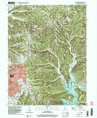
1998 Map of Unionville
USGS Topo · Published 2003About this map
The ridge-and-valley terrain northeast of Bloomington is defined by the significant footprint of the Morgan-Monroe State Forest, which dominates the northern and central portions of the landscape. The settlement of Unionville sits at a crossroads near the center of the sheet, while the northeastern corner captures a portion of Lake Lemon and the feeder waters of Shuffle Creek. To the southwest, the expansion of the city is evident through neighborhoods like Hoosier Acres and Eastern Heights, including the commercial hub of the College Mall Shopping Center.
Find a feature on this map
51 named features on this map. Tap any name to fly to it.
Don’t see what you’re looking for? This feature index may not catch every label — zoom into the map to look around manually.
Map Details
Editions of this 1998 Unionville Map
This is the sole edition of this map. No revisions or reprints were ever made.
Other maps of this area

1908 · Bloomington
USGS Topo · 1:48,000

1910 · Bloomington
USGS Topo · 1:62,500

1942 · Franklin
USGS Topo · 1:125,000

1946 · Belmont
USGS Topo · 1:24,000

1947 · Allens Creek
USGS Topo · 1:24,000

1947 · Unionville
USGS Topo · 1:24,000

1947 · Elkinsville
USGS Topo · 1:24,000

1948 · Hindustan
USGS Topo · 1:24,000

1948 · Morgantown
USGS Topo · 1:24,000

1950 · Belmont
USGS Topo · 1:24,000