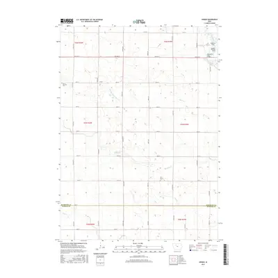
2015 Map of Unique
USGS Topo · Published 2015About this map
Unique sits at the center of this rural landscape, which spans the boundary of Humboldt and Webster counties. The terrain is defined by a series of waterways, most notably the Des Moines River in the northeast corner, crossed by the Berkheimer Bridge and the Des Moines River Bridge. The land is meticulously organized into a grid of county roads, such as Co Hwy P29 and Co Hwy P33, interspersed with numerous drainage features like Drainage Ditch Number 20. This area reveals the persistent agricultural infrastructure of the region, where family history is preserved at the Weaver Township Cemetery and Our Saviors Cemetery. In the northeast, the Humboldt Municipal Airport stands as a modern landmark amidst the traditional section lines. The presence of Indian Creek, Bass Creek, and Deer Creek further illustrates the complex watershed that dictates the placement of farmsteads and transport routes.
Find a feature on this map
42 named features on this map. Tap any name to fly to it.
Don’t see what you’re looking for? This feature index may not catch every label — zoom into the map to look around manually.
Map Details
Editions of this 2015 Unique Map
This is the sole edition of this map. No revisions or reprints were ever made.
Other maps of this area

1923 · Fort Dodge
USGS Topo · 1:62,500

1954 · Fort Dodge
USGS Topo · 1:250,000

1957 · Fort Dodge
USGS Topo · 1:250,000

1958 · Fort Dodge
USGS Topo · 1:250,000

1972 · Livermore
USGS Topo · 1:24,000
1979 · Fort Dodge North
USGS Topo · 1:24,000

1979 · Humboldt
USGS Topo · 1:24,000

1979 · Clare
USGS Topo · 1:24,000

1979 · Gilmore City SW
USGS Topo · 1:24,000

1979 · Unique
USGS Topo · 1:24,000