
1979 Map of Unique
USGS Topo · Published 1979About this map
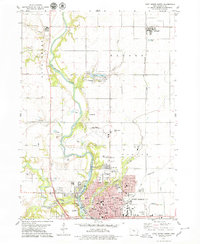
The aptly named settlement of Unique anchors this rural landscape along the border of Humboldt and Webster counties in the late 1970s. This agricultural terrain is defined by the winding course of the Des Moines River in the northeast corner and a network of drainages including Indian Creek, Deer Creek, and Bass Creek. The map provides a detailed view of local infrastructure just north of the county line, featuring the Humboldt Municipal Airport and recreational spaces like Lake Nokomis, the adjacent Golf Course, and Joe Sheldon County Park. Local history and genealogy are well-represented by the location of Township Cem and Our Saviours Cem, alongside several gravel pits and quarries that speak to the region's underlying geology and industry. The map captures a moment when small unincorporated communities and farmstead grids remained the primary social organization for the townships of Avery, Rutland, and Corinth.
Find a feature on this map
21 named features on this map. Tap any name to fly to it.
Don’t see what you’re looking for? This feature index may not catch every label — zoom into the map to look around manually.
Map Details
Editions of this 1979 Unique Map
This is the sole edition of this map. No revisions or reprints were ever made.
Other maps of this area

1923 · Fort Dodge
USGS Topo · 1:62,500

1954 · Fort Dodge
USGS Topo · 1:250,000

1957 · Fort Dodge
USGS Topo · 1:250,000

1958 · Fort Dodge
USGS Topo · 1:250,000

1972 · Livermore
USGS Topo · 1:24,000
1979 · Fort Dodge North
USGS Topo · 1:24,000

1979 · Humboldt
USGS Topo · 1:24,000

1979 · Clare
USGS Topo · 1:24,000

1979 · Gilmore City SW
USGS Topo · 1:24,000

1979 · Gilmore City
USGS Topo · 1:24,000