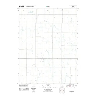
2011 Map of Upland SE
USGS Topo · Published 2011About this map
The Little Blue River meanders across this rural landscape in Kearney County, defining the drainage patterns of south-central Nebraska. This 2011 survey captures a quiet agricultural region where land is organized by the rectilinear grid of Osco Rd, B Rd, and A Rd. Notable water management is evident at the Nelson Reservoir, held by the Nelson Dam, while the central terrain is defined by the headwaters of the Middle Branch Thompson Creek. Local aviation and community history are represented by the Sindt Airport and the well-established grounds of Osco Cemetery and Trinity Cemetery. The map provides a clear look at the intersection of local infrastructure and the natural hydrology of the Thompson Creek branches as they flowed through the Nebraska plains in the early 21st century.
Find a feature on this map
12 named features on this map. Tap any name to fly to it.
Don’t see what you’re looking for? This feature index may not catch every label — zoom into the map to look around manually.
Map Details
Editions of this 2011 Upland SE Map
This is the sole edition of this map. No revisions or reprints were ever made.
Other maps of this area

1897 · Red Cloud
USGS Topo · 1:125,000

1940 · Red Cloud
USGS Topo · 1:62,500

1942 · Red Cloud
USGS Topo · 1:62,500

1955 · Grand Island
USGS Topo · 1:250,000

1957 · Grand Island
USGS Topo · 1:250,000

1958 · Grand Island
USGS Topo · 1:250,000

1969 · Upland
USGS Topo · 1:24,000

1969 · Upland SE
USGS Topo · 1:24,000
1969 · Holstein
USGS Topo · 1:24,000
1969 · Campbell
USGS Topo · 1:24,000