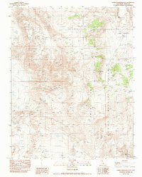
1982 Map of Upper Centennial Flat
USGS Topo · Published 1983About this map
China Lake Naval Weapons Center occupies a significant portion of this high-desert landscape in the early 1980s, reflecting the region's long-standing role in military testing and aerospace research. The terrain is defined by large, arid basins such as Little Cactus Flat and Big Cactus Flat, punctuated by isolated water sources like Upper Centennial Spring and Upper Haiwee Spring. This combination of extreme isolation and topographic variation provided the ideal conditions for sensitive government operations and mining prospects.
Find a feature on this map
19 named features on this map. Tap any name to fly to it.
Don’t see what you’re looking for? This feature index may not catch every label — zoom into the map to look around manually.
Map Details
Editions of this 1982 Upper Centennial Flat Map
This is the sole edition of this map. No revisions or reprints were ever made.
Other maps of this area

1908 · Ballarat
USGS Topo · 1:250,000

1913 · Ballarat
USGS Topo · 1:250,000

1948 · Death Valley
USGS Topo · 1:250,000

1950 · Darwin
USGS Topo · 1:62,500

1951 · Darwin
USGS Topo · 1:62,500

1951 · Keeler
USGS Topo · 1:62,500

1951 · Haiwee Reservoir
USGS Topo · 1:62,500

1951 · Coso Peak
USGS Topo · 1:62,500

1954 · Death Valley
USGS Topo · 1:250,000

1956 · Death Valley
USGS Topo · 1:250,000