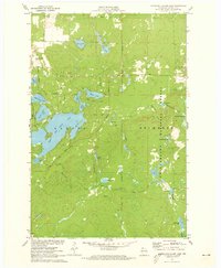
1971 Map of Upper Eau Claire Lake
USGS Topo · Published 1973About this map
Upper Eau Claire Lake serves as the focal point of this northern Wisconsin landscape, surrounded by an intricate network of smaller glacial lakes and springs. Situated within the Chequamegon National Forest and Drummond National Forest, the region shows a transition from water-based recreation to protected timberlands. The presence of the Eau Claire Lakes Airport near Henderson Lake suggests the area's development as a destination for seasonal residents and visitors during the early 1970s.
Find a feature on this map
36 named features on this map. Tap any name to fly to it.
Don’t see what you’re looking for? This feature index may not catch every label — zoom into the map to look around manually.
Map Details
Editions of this 1971 Upper Eau Claire Lake Map
2 editions found
Other maps of this area

1944 · Drummond
USGS Topo · 1:48,000

1944 · Hayward
USGS Topo · 1:48,000

1945 · Highland
USGS Topo · 1:48,000

1947 · Drummond
USGS Topo · 1:48,000

1947 · Chittamo
USGS Topo · 1:48,000

1949 · Chittamo
USGS Topo · 1:48,000

1949 · Highland
USGS Topo · 1:48,000

1953 · Ashland
USGS Topo · 1:250,000

1958 · Ashland
USGS Topo · 1:250,000
1961 · Ellison Lake
USGS Topo · 1:62,500