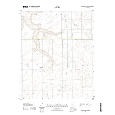
2020 Map of Upper Galestina Canyon
USGS Topo · Published 2020About this map
Upper Galestina Canyon dominates the northern landscape of this McKinley County quadrangle, carving a deep drainage through the high desert terrain. This 2020 topographic record illustrates a high-altitude wilderness where water management is critical for local sustainability, evidenced by the Upper Galestina Number One A Reservoir and Upper Galestina Number 7 Reservoir. The map highlights the sparse transportation network within the region, primarily served by roads such as Indian Svc Rte 8 and Indian Svc Rte 13. In the southern portion of the quadrangle, the Trujillo Draw provides a significant drainage feature alongside the lesser-known Guillermo Canyon. This map serves as an essential reference for understanding the modern boundary between McKinley and Cibola counties, following a straight east-west line through the rugged canyon country.
Find a feature on this map
12 named features on this map. Tap any name to fly to it.
Don’t see what you’re looking for? This feature index may not catch every label — zoom into the map to look around manually.
Map Details
Editions of this 2020 Upper Galestina Canyon Map
This is the sole edition of this map. No revisions or reprints were ever made.
Other maps of this area

1886 · Wingate
USGS Topo · 1:250,000

1892 · Wingate
USGS Topo · 1:250,000

1954 · Saint Johns
USGS Topo · 1:250,000

1954 · Gallup
USGS Topo · 1:250,000

1957 · Saint Johns
USGS Topo · 1:250,000

1958 · Gallup
USGS Topo · 1:250,000

1958 · Saint Johns
USGS Topo · 1:250,000

1959 · Gallup
USGS Topo · 1:250,000

1962 · Gallup
USGS Topo · 1:250,000

1962 · Saint Johns
USGS Topo · 1:250,000