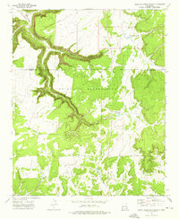
1972 Map of Upper Galestina Canyon
USGS Topo · Published 1976About this map
The Zuni Indian Reservation dominates this 1970s landscape, where the dramatic incision of Galestina Canyon snakes across the high plateau. This survey provides a detailed look at the resource management and water infrastructure of the era, documenting features like the Upper Galestina No 1A Reservoir and the Upper Galestina No 7 Reservoir. These small impoundments, alongside landmarks such as the ECW No 7 Windmill, suggest a pastoral economy reliant on carefully managed water sources in an arid environment. The map also records the boundary line between McKinley and Valencia counties, cutting through a terrain of deep drainage systems like Trujillo Draw and Guillermo Canyon. A single Quarry is the primary industrial marker in a region otherwise defined by its topography and reservation lands.
Find a feature on this map
10 named features on this map. Tap any name to fly to it.
Don’t see what you’re looking for? This feature index may not catch every label — zoom into the map to look around manually.
Map Details
Editions of this 1972 Upper Galestina Canyon Map
This is the sole edition of this map. No revisions or reprints were ever made.
Other maps of this area

1886 · Wingate
USGS Topo · 1:250,000

1892 · Wingate
USGS Topo · 1:250,000

1954 · Saint Johns
USGS Topo · 1:250,000

1954 · Gallup
USGS Topo · 1:250,000

1957 · Saint Johns
USGS Topo · 1:250,000

1958 · Gallup
USGS Topo · 1:250,000

1958 · Saint Johns
USGS Topo · 1:250,000

1959 · Gallup
USGS Topo · 1:250,000

1962 · Gallup
USGS Topo · 1:250,000

1962 · Saint Johns
USGS Topo · 1:250,000