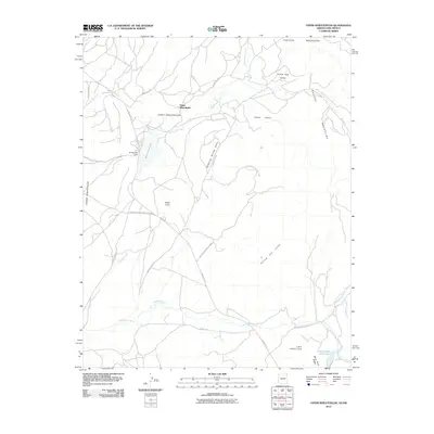
2010 Map of Upper Wheatfields
USGS Topo · Published 2010About this map
Upper Wheatfields and the high country of the Chuska Mountains define this northern Arizona landscape on the border of New Mexico. The area is characterized by a network of essential water sources and mountain valleys, including Bubbling Spring Valley and the expansive Prairie Dog Valley. Central to the region's geography is Wheatfields Lake, regulated by the Wheatfield Dam, which serves as a vital hub for the surrounding settlements of White Cone and Little White Cone.
Find a feature on this map
27 named features on this map. Tap any name to fly to it.
Don’t see what you’re looking for? This feature index may not catch every label — zoom into the map to look around manually.
Map Details
Editions of this 2010 Upper Wheatfields Map
This is the sole edition of this map. No revisions or reprints were ever made.
Other maps of this area

1889 · Chaco
USGS Topo · 1:250,000

1892 · Chaco
USGS Topo · 1:250,000

1892 · Canyon De Chelly
USGS Topo · 1:250,000

1953 · Sanostee
USGS Topo · 1:62,500

1954 · Shiprock
USGS Topo · 1:250,000

1955 · Sonsala Butte 4 SE
USGS Topo · 1:24,000

1955 · Sonsala Butte 4 NW
USGS Topo · 1:24,000

1955 · Sonsala Butte 1 SE
USGS Topo · 1:24,000

1955 · Sonsala Butte 1 SW
USGS Topo · 1:24,000
1955 · Sonsala Butte 4 SW
USGS Topo · 1:24,000
Featured Places
- Shiprock Agency
- Chinle Agency, AZ
- Fort Defiance Agency
- Upper Wheatfields, Chinle Agency
- San Juan County, NM