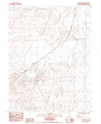
1985 Map of Upsal Hogback
USGS Topo · Published 1985About this map
The California Emigrant Trail (Carson Route) cuts through the arid landscape of the Fortymile Desert, tracing a historic path of western migration across Nevada's Churchill County. This mid-1980s terrain is defined by the stark transition from the Hot Springs Mountains in the northwest to the low-lying Lahontan Valley and the expansive Carson Sink. The volcanic rise of the Upsal Hogback stands as a prominent landmark amidst the numerous Alkali Flats that dominate the basin floor.
Find a feature on this map
20 named features on this map. Tap any name to fly to it.
Don’t see what you’re looking for? This feature index may not catch every label — zoom into the map to look around manually.
Map Details
Editions of this 1985 Upsal Hogback Map
This is the sole edition of this map. No revisions or reprints were ever made.
Other maps of this area

1908 · Carson Sink
USGS Topo · 1:250,000

1910 · Carson Sink
USGS Topo · 1:250,000

1950 · Stillwater
USGS Topo · 1:62,500

1951 · Soda Lake
USGS Topo · 1:62,500

1951 · Carson Sink
USGS Topo · 1:62,500

1951 · Desert Peak
USGS Topo · 1:62,500

1957 · Reno
USGS Topo · 1:250,000

1959 · Reno
USGS Topo · 1:250,000

1960 · Reno
USGS Topo · 1:250,000

1979 · Carson Sink
USGS Topo · 1:100,000