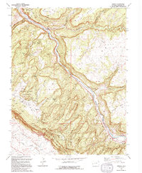
1994 Map of Uravan
USGS Topo · Published 1994About this map
The San Miguel River carves a deep path through this Montrose County landscape, defining a region historically shaped by intense mineral exploration. This 1994 update of mid-century surveys highlights the extensive Department of Energy Uranium Reserve, an area once critical to the nation's nuclear history. The terrain is marked by numerous active and legacy operations, from the Sunbeam Mine and Forty-five Ninety Mine to the clustered shafts of Long Park No 6 Mine.
Find a feature on this map
40 named features on this map. Tap any name to fly to it.
Don’t see what you’re looking for? This feature index may not catch every label — zoom into the map to look around manually.
Map Details
Editions of this 1994 Uravan Map
This is the sole edition of this map. No revisions or reprints were ever made.
Other maps of this area

1916 · Paradox Valley
USGS Topo · 1:125,000

1922 · Paradox Valley
USGS Topo · 1:125,000

1948 · Bull Canyon
USGS Topo · 1:24,000

1948 · Uravan
USGS Topo · 1:24,000

1948 · Naturita NW
USGS Topo · 1:24,000

1949 · Bull Canyon
USGS Topo · 1:24,000

1949 · Davis Mesa
USGS Topo · 1:24,000

1949 · Uravan
USGS Topo · 1:24,000

1949 · Naturita NW
USGS Topo · 1:24,000

1949 · Atkinson Creek
USGS Topo · 1:24,000