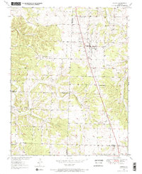
1950 Map of Urbana
USGS Topo · Published 1967About this map
Urbana and Louisburg anchor the eastern corridor of this mid-century survey, situated along the primary north-south route of highway 65. The landscape is defined by the intersection of three counties, where the boundaries of Dallas Co, Hickory Co, and Polk Co meet. The settlement pattern reveals a series of small, rural community centers such as Huckaby and Rimby, many of which were built around local institutions like Star Ridge Sch and several country churches.
Find a feature on this map
26 named features on this map. Tap any name to fly to it.
Don’t see what you’re looking for? This feature index may not catch every label — zoom into the map to look around manually.
Map Details
Editions of this 1950 Urbana Map
2 editions found
Other maps of this area

1884 · Bolivar
USGS Topo · 1:125,000

1892 · Bolivar
USGS Topo · 1:125,000

1949 · Sentinel
USGS Topo · 1:24,000

1950 · Sentinel
USGS Topo · 1:24,000

1950 · Buffalo NW
USGS Topo · 1:24,000

1950 · Polk
USGS Topo · 1:24,000

1950 · Urbana
USGS Topo · 1:24,000

1951 · Buffalo NW
USGS Topo · 1:24,000

1951 · Urbana
USGS Topo · 1:24,000

1951 · Polk
USGS Topo · 1:24,000