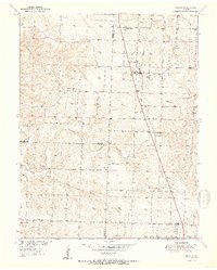
1951 Map of Urbana
USGS Topo · Published 1951About this map
Urbana and the surrounding rural communities of Louisburg, Huckaby, and Rimby serve as the primary focal points of this 1951 survey, which documents the landscape of Dallas, Hickory, and Polk Counties just after mid-century. The settlement pattern is defined by upland ridges and a network of country churches and schools that anchored rural life, including Bower Chapel, Pleasant Ridge Ch, and the Star Ridge Sch in the southwest.
Find a feature on this map
27 named features on this map. Tap any name to fly to it.
Don’t see what you’re looking for? This feature index may not catch every label — zoom into the map to look around manually.
Map Details
Editions of this 1951 Urbana Map
2 editions found
Other maps of this area

1884 · Bolivar
USGS Topo · 1:125,000

1892 · Bolivar
USGS Topo · 1:125,000

1949 · Sentinel
USGS Topo · 1:24,000

1950 · Sentinel
USGS Topo · 1:24,000

1950 · Buffalo NW
USGS Topo · 1:24,000

1950 · Polk
USGS Topo · 1:24,000

1950 · Urbana
USGS Topo · 1:24,000

1951 · Buffalo NW
USGS Topo · 1:24,000

1951 · Urbana
USGS Topo · 1:24,000

1951 · Polk
USGS Topo · 1:24,000