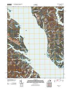
2010 Map of Urbanna
USGS Topo · Published 2010About this map
Urbanna and the surrounding shores of the Rappahannock River serve as the focal point for this 2010 coastal survey. The map details a landscape deeply connected to the Chesapeake Bay watershed, where tidal creeks like Lagrange Creek and Urbanna Creek carve into the Middlesex County shoreline. Genealogical interests are well-served by the presence of numerous burial sites, including the Saint Marys Whitechapel Cemetery and the Arthur Lee Family Cemetery.
Find a feature on this map
103 named features on this map. Tap any name to fly to it.
Don’t see what you’re looking for? This feature index may not catch every label — zoom into the map to look around manually.
Map Details
Editions of this 2010 Urbanna Map
This is the sole edition of this map. No revisions or reprints were ever made.
Other maps of this area

1916 · Kilmarnock
USGS Topo · 1:48,000

1917 · Heathsville
USGS Topo · 1:48,000

1917 · Urbanna
USGS Topo · 1:62,500

1917 · Morattico
USGS Topo · 1:62,500

1917 · Kilmarnock
USGS Topo · 1:62,500

1918 · Morattico
USGS Topo · 1:62,500

1926 · Morattico
USGS Topo · 1:62,500

1942 · Kilmarnock
USGS Topo · 1:62,500

1943 · Richmond
USGS Topo · 1:250,000

1944 · Morattico
USGS Topo · 1:31,680