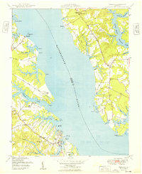
1949 Map of Urbanna
USGS Topo · Published 1949About this map
Urbanna serves as a central hub on the southern bank of the Rappahannock River during the late 1940s, characterized by its tidal creek frontage and maritime infrastructure. The map reveals a landscape defined by deep water access, where Urbanna Wharf and the Remlik Wharf along Lagrange Creek supported local commerce before the widespread modernization of regional transport. Across the river in Lancaster Co, small agrarian and fishing communities like Ottoman, Bertrand, and Mollusk are connected by narrow roads winding between the fingers of the Corrotoman River. The presence of numerous historical sites, such as the St Marys Chapel and the significant Corbin Hall estate, suggests a deep-rooted social fabric tied to the waterfront. This survey, based on aerial photography from the mid-1940s, captures the peninsula’s reliance on its complex network of "prongs" and creeks, including Ewells Prong and Robinson Creek.
Find a feature on this map
68 named features on this map. Tap any name to fly to it.
Don’t see what you’re looking for? This feature index may not catch every label — zoom into the map to look around manually.
Map Details
Editions of this 1949 Urbanna Map
This is the sole edition of this map. No revisions or reprints were ever made.
Other maps of this area

1916 · Kilmarnock
USGS Topo · 1:48,000

1917 · Heathsville
USGS Topo · 1:48,000

1917 · Urbanna
USGS Topo · 1:62,500

1917 · Morattico
USGS Topo · 1:62,500

1917 · Kilmarnock
USGS Topo · 1:62,500

1918 · Morattico
USGS Topo · 1:62,500

1926 · Morattico
USGS Topo · 1:62,500

1942 · Kilmarnock
USGS Topo · 1:62,500

1943 · Richmond
USGS Topo · 1:250,000

1944 · Morattico
USGS Topo · 1:31,680