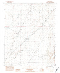
1983 Map of Ute
USGS Topo · Published 1984About this map
The Moapa River Indian Reservation dominates the western portion of this 1980s landscape, illustrating the spatial boundaries of tribal lands in southern Nevada. This arid region is bisected by two major transportation corridors: the Union Pacific railroad and a dual-lane highway marked as California, which facilitates travel between the Ute Interchange and Byron Interchange. The presence of a Borrow Pit and several Prospects suggests a landscape shaped by both infrastructural development and localized mineral exploration near the North Muddy Mountains. This survey documents a critical junction of rail and road infrastructure through a largely unpopulated desert corridor, where the seasonal drainage of the Wash serves as a primary topographic marker for the basin.
Find a feature on this map
10 named features on this map. Tap any name to fly to it.
Don’t see what you’re looking for? This feature index may not catch every label — zoom into the map to look around manually.
Map Details
Editions of this 1983 Ute Map
This is the sole edition of this map. No revisions or reprints were ever made.
Other maps of this area

1886 · Saint Thomas
USGS Topo · 1:250,000

1893 · Saint Thomas
USGS Topo · 1:250,000

1926 · Boulder Canyon
USGS Topo · 1:96,000

1952 · Dry Lake
USGS Topo · 1:62,500

1953 · Muddy Peak
USGS Topo · 1:62,500

1954 · Las Vegas
USGS Topo · 1:250,000

1957 · Las Vegas
USGS Topo · 1:250,000

1958 · Arrow Canyon
USGS Topo · 1:62,500

1958 · Moapa
USGS Topo · 1:62,500

1959 · Las Vegas
USGS Topo · 1:250,000